Geographic Information Systems (GIS)
GIS consists of integrated computer hardware and software that store, manage, analyze, edit, output, and visualize geographic data. GIScience, the academic discipline that studies GIS, is often considered a subdiscipline of geography within technical geography.
History and Development
While digital GIS dates to the mid-1960s, many of the geographic concepts and methods that GIS automates date back decades earlier. One of the earliest known instances in which spatial analysis was used came from the field of epidemiology in 1832. In 1854, epidemiologist John Snow used spatial analysis to determine the source of a cholera outbreak in London. Early 20th-century developments included photozincography, which allowed maps to be split into layers, and the introduction of a street network into the U.S. Census Bureau's DIME (Dual Independent Map Encoding) system. The first true operational GIS was developed in Ottawa, Ontario, Canada, in 1963 by the federal Department of Forestry and Rural Development.
GIS Software
GIS software is a general-purpose application program designed to be used in many individual geographic information systems in a variety of application domains. Starting in the late 1970s, many software packages have been created specifically for GIS applications. Esri's ArcGIS currently dominates the GIS market. Other examples include Autodesk and MapInfo Professional and open-source programs such as QGIS, GRASS GIS, MapGuide, and Hadoop-GIS.
Geospatial Data Management
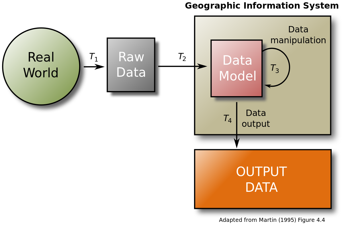
The core of any GIS is a database that contains representations of geographic phenomena, modeling their geometry (location and shape) and their properties or attributes. GIS data represents phenomena that exist in the real world, such as roads, land use, elevation, trees, waterways, and states. Trajectories, processes, and masses are represented less commonly or indirectly, or modeled in analysis procedures rather than data. Traditionally, there are two broad methods used to store data in a GIS for both kinds of abstractions mapping references: raster images and vector.
Spatial Analysis
GIS spatial analysis is a rapidly changing field, and GIS packages increasingly include analytical tools as standard built-in facilities, as optional toolsets, as add-ins, or 'analysts.' In many instances, these are provided by the original software suppliers or collaborative noncommercial development teams. The increased availability has created a new dimension to business intelligence termed "spatial intelligence," which, when openly delivered via intranet, democratizes access to geographic and social network data. Geospatial intelligence, based on GIS spatial analysis, has also become a key element for security.
Uses
Since its origin in the 1960s, GIS has been used in an ever-increasing range of applications, including:
- Scientific research
- Resource management
- Strategic, tactical, and operational decision-making
- Applications concerning the human world, the natural world, or both
- Implementations in government, business, non-profit organizations, and personal use
Societal Implications
GIS has significant societal implications, including ethical concerns, copyright, privacy, and censorship issues. GIS also has the potential to increase citizen trust in government and be used as a tool for public participation.
Education and Local Government
GIS is increasingly being recognized as a tool that can be used in the classroom, particularly in geography education. It is also proven as an organization-wide, enterprise, and enduring technology that continues to change how local government operates.